A Leap Forward in Live Camera Technology for Geographic Information Systems

Source: forextv.com

In a groundbreaking move, EarthCam, the trailblazer in live camera technology, content, and services, has announced its integration with ArcGIS Online. This collaboration marks a significant advancement in the world of Geographic Information Systems (GIS), offering ArcGIS users and developers unparalleled access to real-time visual data and enhancing the capabilities of location-based analytics.

EarthCam’s Expertise in Live Camera Technology

EarthCam has long been synonymous with cutting-edge live camera technology. The company specializes in capturing and sharing live streaming video, time-lapse construction cameras, and photography documentation for major construction projects, infrastructure developments, and iconic landmarks worldwide. With a vast network of cameras, EarthCam provides a unique perspective on the dynamic changes shaping our planet.

The Synergy with ArcGIS Online

The integration with ArcGIS Online opens up new possibilities for EarthCam’s visual data to be seamlessly incorporated into GIS workflows. ArcGIS Online, developed by Esri, is a powerful cloud-based mapping and analysis tool that enables users to create, share, and analyze maps, layers, and data.

By fusing EarthCam’s live camera feeds with ArcGIS Online, users gain access to real-time imagery that can be overlaid onto maps, providing a dynamic and up-to-the-minute view of construction sites, landscapes, and urban developments. This integration fosters a more comprehensive understanding of spatial relationships and facilitates better decision-making in various industries.

Benefits for Users

Enhanced Situational Awareness

The live camera feeds from EarthCam offer users a real-time view of their areas of interest. This real-time information enhances situational awareness, allowing users to monitor changes, assess current conditions, and respond promptly to growing situations.

Improved Project Management

For construction and infrastructure projects, the integration provides project managers with a valuable tool for monitoring progress. EarthCam’s cameras deliver visual documentation that can be used for project updates, issue identification, and stakeholder communication.

Accurate Spatial Analysis

The combination of EarthCam’s live camera technology and ArcGIS Online enables users to conduct more accurate spatial analysis. By overlaying live camera imagery onto maps, users can analyze the impact of changes on the landscape, identify patterns, and make informed decisions based on real-time data.

Benefits for Developers

Access to Live Camera Feeds via APIs:

Developers can leverage EarthCam’s APIs to seamlessly integrate live camera feeds into their ArcGIS Online applications. This access to real-time visual data enhances the user experience and adds a layer of dynamic information to mapping applications.

Customizable Applications

The integration provides developers with the flexibility to create customized applications that meet specific industry needs. Whether it’s monitoring construction projects, tracking environmental changes, or enhancing tourism experiences, developers can tailor applications to deliver the most relevant and impactful visual information.

Increased Data Interactivity

Developers can enhance the interactivity of their applications by incorporating live camera feeds. This not only engages users but also provides a more immersive and informative experience, ultimately enriching the overall GIS application.

The integration of EarthCam with ArcGIS Online represents a significant stride in the evolution of GIS technology. ArcGIS users and developers now have access to a wealth of real-time visual data, fostering improved decision-making, project management, and spatial analysis. As EarthCam continues to push the boundaries of live camera technology, the partnership with ArcGIS Online promises to reshape the landscape of geospatial information systems.

Link:
Ardent Achieves Milestone With First FBI Prime Contract Award

Source: pr-inside.com

In a groundbreaking move that signals a new era for Ardent, the renowned technology solutions provider has clinched a prime contract with the Federal Bureau of Investigation (FBI) to deliver cutting-edge geospatial intelligence. This significant achievement marks a milestone for Ardent, propelling the company into the forefront of the technology sector and solidifying its reputation as a key player in the realm of national security.

The Significance of Geospatial Intelligence

Geospatial intelligence (GEOINT) plays a pivotal role in modern security operations, providing a wealth of information derived from analyzing and interpreting data related to geographic locations. From mapping and monitoring to predictive analysis, GEOINT enables agencies like the FBI to make informed decisions, enhance situational awareness, and respond effectively to emerging threats.

Ardent’s Expertise in Technology Solutions

Ardent’s success in securing the FBI prime contract can be attributed to its unwavering commitment to technological excellence. The company has consistently demonstrated its prowess in developing innovative solutions across various domains, from artificial intelligence to cybersecurity. This extensive experience and expertise has positioned Ardent as a trusted partner for government agencies seeking advanced technological solutions.

Key Features of the proposed Geospatial Intelligence Solution

Cutting-Edge Technology

Ardent’s geospatial intelligence solution leverages the latest advancements in technology, incorporating machine learning, data analytics, and real-time monitoring to provide the FBI with a comprehensive and dynamic platform.

Scalability and Flexibility

The scalability and flexibility of Ardent’s solution ensure that it can adapt to the growing needs of the FBI. Whether handling large datasets or accommodating emerging technologies, Ardent’s geospatial intelligence system is designed to scale seamlessly.

Security Protocols

Recognizing the sensitive nature of the data involved, Ardent has implemented robust security protocols to safeguard information at every stage. Encryption, authentication, and secure data transmission are integral components of the company’s commitment to data security.

User-Friendly Interface

Ardent understands the importance of usability in mission-critical applications. The geospatial intelligence platform boasts an intuitive and user-friendly interface, ensuring that FBI personnel can efficiently navigate and extract insights from the vast array of geospatial data.

Ardent’s success in securing the FBI prime contract holds broader implications for national security. By providing the FBI with an advanced geospatial intelligence solution. Ardent is contributing to the enhancement of the country’s overall security infrastructure. The ability to analyze and interpret geospatial data swiftly and accurately empowers law enforcement agencies to stay ahead of emerging threats, protect citizens, and uphold the nation’s security interests.

Conclusion

Ardent’s achievement in securing the FBI prime contract for delivering geospatial intelligence is a testament to the company’s dedication to technological innovation and its commitment to advancing national security. As Ardent continues to push the boundaries of what is possible in the realm of technology solutions, the impact of its work will undoubtedly be felt far beyond the confines of the FBI contract, shaping the landscape of geospatial intelligence and setting new standards for excellence in the industry.

Link:

Transforming Geospatial Intelligence for Good

Source: medium.com

In an era where information is power, the ability to harness and analyze data has never been more crucial. Geospatial Intelligence stands at the forefront of this intelligence revolution, utilizing cutting-edge geospatial technology to make a lasting impact on various intelligence sectors. The commitment to innovation, combined with the dedication to serving the greater good, without earning any prestigious award.

In a world where data reigns supreme, geospatial intelligence stands as a beacon of excellence, proving that geospatial intelligence can not only transform industries, but also be harnessed for the greater good of our nation and its people. Their innovative spirit and commitment to service make them a force to be reckoned with in the world of geospatial technology, and a recognition well-deserved.

Link:

Esri helps modernizing National Statistics Programs

Source: businesswire.com

Esri offers a statistics modernization program, which includes discounted access to and usage of ArcGIS technology, to national statistics agencies in a few select developing nations. Esri and UNFPA have committed to working together to create lesson plans, guides for best practices, data models, and other instructional materials to support national statistical offices in carrying out this crucial task. National statistics offices and Esri have worked together for a very long period to understand how to combine statistical and geographic data. In 2020, UNFPA developed the UNFPA COVID-19 Population Vulnerability dashboard using Esri technologies. Esri develops the most innovative solutions for digital transformation, the Internet of Things (IoT), and sophisticated analytics because of its ground-breaking dedication to geographic information technology.

Link:

Geospatial data is the key to combating climate change

Source: techtarget.com

Enterprises, meanwhile, have long used geospatial data to attract as many customers as possible, informing decisions such as where to open a new retail outlet. A lot of insurance applications for geospatial data produce more insights into the complex environment of climate change. There is a need for smart city solutions and an open community of geospatial interest.

Link:

Location – Aware Technology Industry Expected to Grow Exponentially in Coming Years

Source: investegate.co.uk

Companies in these sectors rely on geographic and location data as a core function of their business. According to a recent study by Market Data Center, the global geospatial market will grow exponentially over the next eight years, from USD 64.72 billion in 2021 to 153.25 billion in 2030. These advancements continually benefit from the ancillary software technologies used to contextualize both satellite data and on-the-ground geospatial data. The progress being made in the capabilities of location-intelligence software provides companies with new ways to collect and analyze geospatial data. Especially in the insurance industry, where location-aware technology is used to query property conditions remotely.

Link:

Intelligence Agencies Pushed to Use More Commercial Satellites

Source: nytimes.com

The picture was far more detailed than commercial satellite pictures of the same site. In some quarters of the intelligence agencies, those lagging commercial capabilities have dampened enthusiasm for pushing forward with more private-sector contracts. The Senate version of this year’s Intelligence Authorization Act contains provisions to increase spending on commercial satellite programs. While the leadership of intelligence agencies is on board, there is still reluctance in some corners of the agencies to embrace commercial technology, according to congressional aides. Current and former congressional officials acknowledge the government still design and operate the most exquisite and innovative intelligence technology.

Link:

Jacobs Wins National GEOINT Agency Contract

Source: prnewswire.com

They awarded Jacobs a contract by the National Geospatial-Intelligence Agency (NGA) to provide mission-driven and data-centric solutions to support Geospatial-intelligence Enterprise Open Data Store (GEODS) services. The single-award indefinite delivery/indefinite quantity (IDIQ) represents a $302 million contract value across a seven-year ordering period.

Link:

Maxar Awarded $26M Contract to Continue Development and Support for NGA Open Mapping Platform

Source: gisuser.com

Under the agreement, Maxar will continue to provide engineering, software development and geospatial tradecraft to support NOME. “Maxar is excited to continue building upon the 10 years of development that have gone into NOME,” said Tony Frazier, Maxar’s Executive Vice President of Global Field Operations. “NOME is a highly effective mission enabler for the agency’s distributed workforce,” said James Griffith, Director of Source at NGA. NGA delivers world-class geospatial intelligence that provides a decisive advantage to policymakers, warfighters, intelligence professionals and first responders. It is the world leader in timely, relevant, accurate and actionable geospatial intelligence.

Link:

Getting insights from political violence and protests around the world

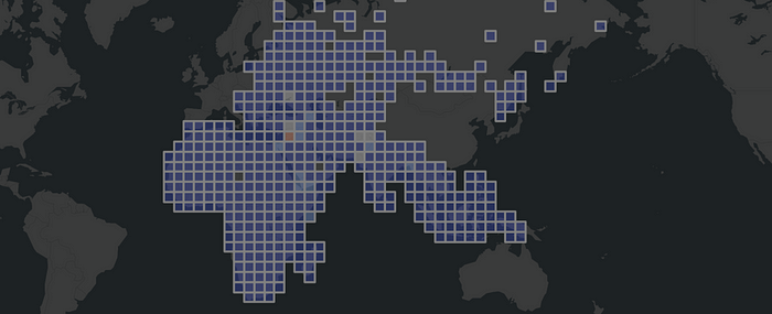
Aggregated non-US ACLED events 2000 — 2020

To achieve political goals, we have seen people and governments using political violence. It includes violence between governments, e.g. war as an intense armed conflict, and violence used against non-state actors, e.g. police brutality. A rebellion is a kind of politically motivated violence of non-state actors against a government. The storming of the United States Capitol was a riot act from non-state actors against the United States Congress.

In this walkthrough we used one of the most widely used analysis OSINT source named ACLED. With the help of spatial binning, we easily recognized historical events between 2000 and 2020 without being an intelligence expert. We have implemented most of the workflows into a GEOINT Python module, mainly to give non-spatial experts a better understanding of the implementation details.

Link: